
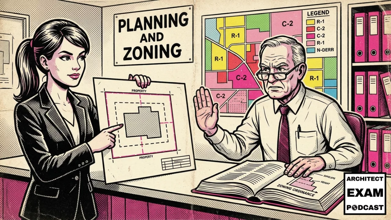

Zoning controls what you can build on a piece of land, how big it can be, and where it can sit on the site. This guide covers setbacks, easements, floor area ratio, lot coverage, building height limits, zoning variances, conditional use permits, nonconforming uses, planned unit developments, and restrictive covenants, with memory hooks and custom diagrams for every term.
This podcast is also available on YouTube, Spotify, and Apple Podcasts.
Test yourself! This episode has a free 10-question zoning fundamentals quiz at the bottom of this page.
Zoning vs. Building Code
You own the land. You pay the taxes. You pay the mortgage. Your name is on the deed.
But when it comes to what you can actually build on it? The city gets a vote.
They get to tell you how tall, how close to the property line, how much of the lot you can cover, and in some cases what you’re even allowed to use the land for.
And that’s not the building code. That’s a completely separate system called zoning. Different rules, different department, different review process.
Confusing the two is one of the most common mistakes many people make.
The building code, primarily the IBC, is about life safety. Is the building safe to occupy? It covers construction type, fire protection, egress requirements, and structural systems. It’s reviewed by the building department.
The building code asks: how do you build it safely?
Zoning is about land use and development intensity. Can you build this type of building on this piece of land? How big can it be? How close to the edges? How tall? How much parking? It’s administered by the planning or zoning department.
Zoning asks: what can you build here, and how much of it?
Different questions. Different authorities. Different appeals processes.
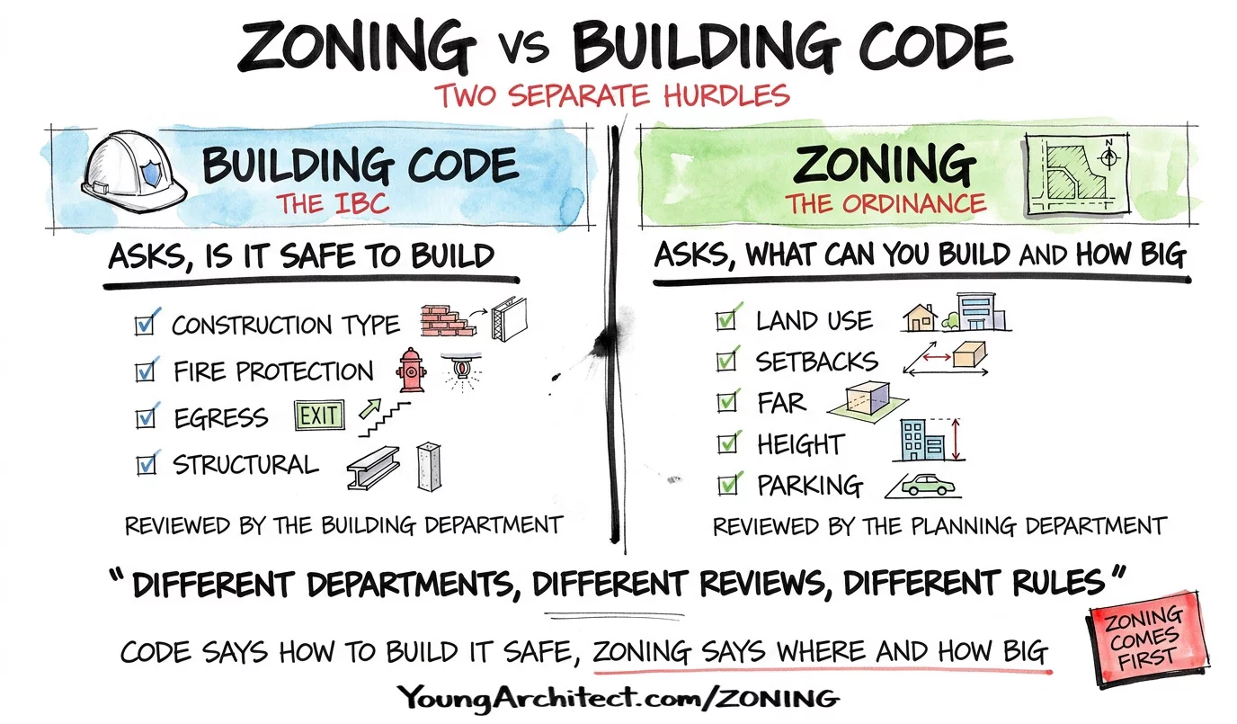
You can comply with zoning and still fail the building code. Or you can pass every building code requirement and still violate zoning regulations. They’re separate hurdles. Clearing one doesn’t mean you’ve cleared the other.
And in practice, zoning comes first. If you’ve ever spent time at a permit center, you know this.
Before the plans examiner reviews your occupancy classifications, construction types, or means of egress, the zoning department has to sign off.
If the zoning doesn’t work, nobody is looking at your building code compliance yet.
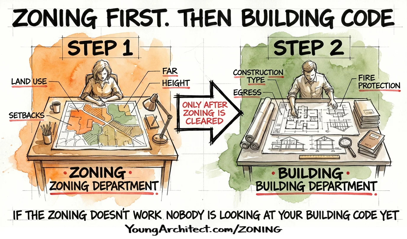
Every piece of land in a jurisdiction falls within a designated zone on the official zoning map. The local zoning ordinance spells out what’s allowed in each zone, from permitted uses to dimensional limits. If you’ve never pulled up the zoning map for a project site before diving into design, you’re skipping the first step.
Code says how to build it safe. Zoning says where and how big.
NCARB’s published objectives point toward this distinction directly. PA Objective 2.2 specifically asks you to identify zoning and land use requirements as distinct from building code requirements.
Understanding that zoning as a legislative framework governs land use while building codes govern construction safety is the foundation for everything else in this post.
Setbacks and Encroachment
Your lot is not a blank canvas. There are invisible lines all over it, and those lines determine the area you actually get to work with.
A setback is the required distance from the property line to the face of the building. It’s the buffer zone the city requires between your building and the edges of your lot.
Think of it like a picture inside a picture frame. The picture is your building. The matting around the picture is the setback. You can’t push the picture all the way to the edge of the frame. There has to be space around it.
Most zoning codes specify different setback requirements for each side of the lot, and they’re often different dimensions:
- Front setback: might be 25 feet
- Side setbacks: might be 10 feet each
- Rear setback: might be 20 feet
You can’t build anything permanent in those zones, with limited exceptions like fences, landscaping, or retaining walls depending on the jurisdiction.
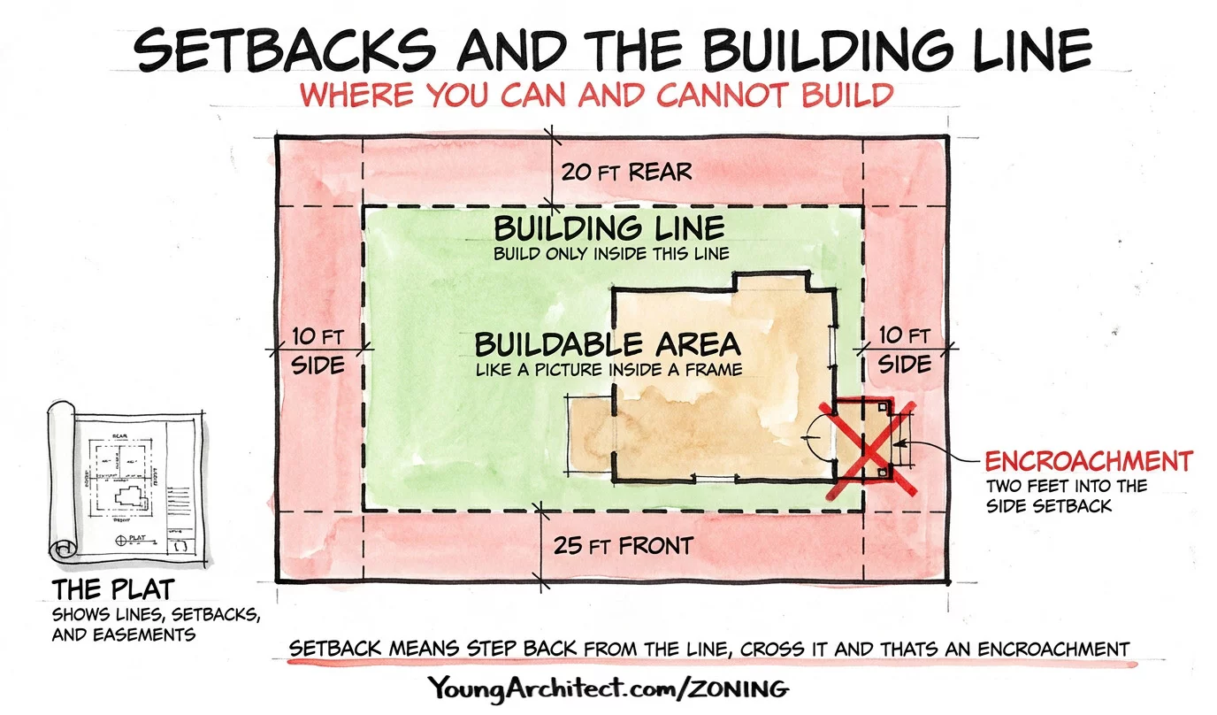
The building line (sometimes called the building setback line) is the line beyond which you CAN build. It’s established by the setback requirements, and it’s typically shown on the plat.
The plat is the recorded legal document for the property. It shows property boundaries, setbacks, easements, rights-of-way, and utility locations all in one drawing. If you haven’t looked at the plat for a project site, you’re flying blind.
Now, what happens if someone builds into a setback or over a property line?
That’s called an encroachment, and it’s not just a code violation. It can mean tearing the structure down, applying for a variance after the fact, or facing a lawsuit from a neighbor.
Imagine finishing a building and getting a letter from the city that says your porch is two feet into the side setback. That’s an encroachment. And “we didn’t realize” is not a defense.
Setback means step back from the line. Cross it and that’s an encroachment.
Easements
Setbacks are about how far your building has to stay from the property line. But there’s another set of restrictions that can limit where you build, and these ones live inside your property.
An easement is a legal right for someone else to use a portion of your land for a specific purpose. You still own the land. You still pay taxes on it. But someone else has rights to it.
Think of it like giving someone a permanent hallway pass through your house. You own the hallway. You pay the mortgage on it. But they can walk through it whenever they need to, and you can’t wall it off.
There are three common types of easements you need to know.
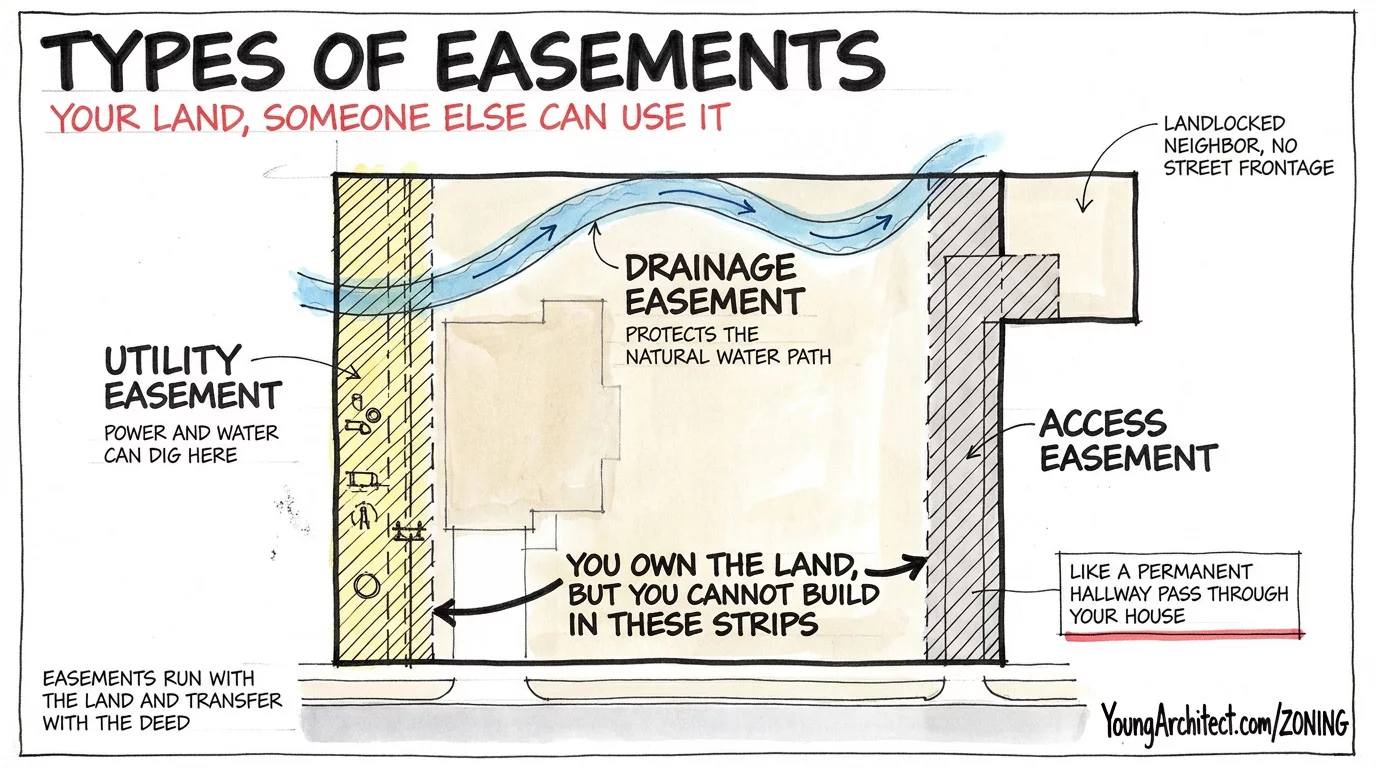
Utility easement. This gives the power company, water department, or telecom provider the right to access a strip of your property to install and maintain their infrastructure. You can’t build a permanent structure over it because they might need to dig it up at any time. That beautiful garden you planted over the water main? They’ll rip it out without a second thought if they need to get to the pipe.
Drainage easement. This protects the natural path that water follows across your property. You can’t block it, reroute it, or build over it, because doing so could flood your neighbor’s property downstream.
Access easement. This gives a neighbor whose property is landlocked (meaning it has no direct street frontage) the legal right to cross your land to reach theirs. They need a way in and out, and your property is the path.
Easements run with the land. They’re not personal agreements between two neighbors that go away when someone sells. They’re attached to the property itself and transfer with the deed. Buy a property with a utility easement across the backyard and that property easement is now yours to live with.
You typically cannot build permanent structures in an easement on property. So when you’re evaluating a site, every easement you find shrinks the area you actually get to design on.
For a deeper look at the legal framework, Cornell Law Institute’s legal definition of an easement covers the distinction between appurtenant and in gross easements, affirmative and negative easements, and the legal mechanisms that create them.
Easement means someone else’s ease of access to your land.
Easement vs. Right-of-Way
Easements get confused with another term constantly, and getting them mixed up will lead you to the wrong answer.
A right-of-way is land that’s been dedicated for public use. Usually for streets, sidewalks, and public utilities.
The key difference is ownership.
With an easement, you still own the land. Someone else just has rights to use it. With a right-of-way, it’s usually not your land at all. It’s dedicated to public use.
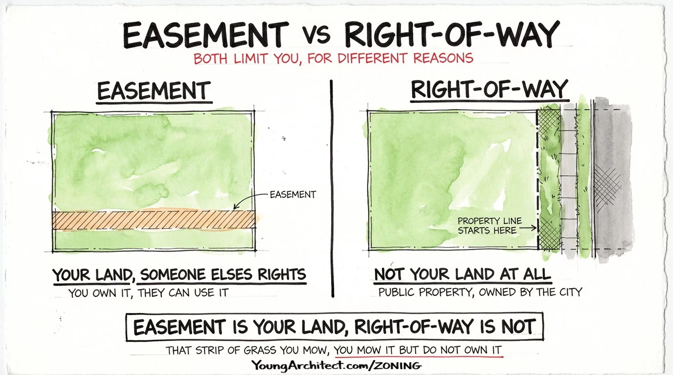
Your property line typically starts at the edge of the right-of-way. That strip of grass between the sidewalk and the street that you mow every weekend? That’s probably not your land. It’s part of the public right-of-way. You maintain it, but you don’t own it.
Easement: your land, someone else’s rights.
Right-of-way: not your land at all.
Both limit where you can build, but for completely different legal reasons. When you’re looking at a site plan and trying to figure out your actual buildable area, you need to identify both.
Buildable Area
This is where it all clicks.
Take your lot. Subtract the setbacks on all sides. Subtract any easements running through the property. Subtract the right-of-way, which isn’t even your land to begin with.
What’s left is your buildable area. That’s the actual canvas you’re designing on. Not the full lot. Not the area inside the property lines. The area that’s left after every constraint has taken its piece.
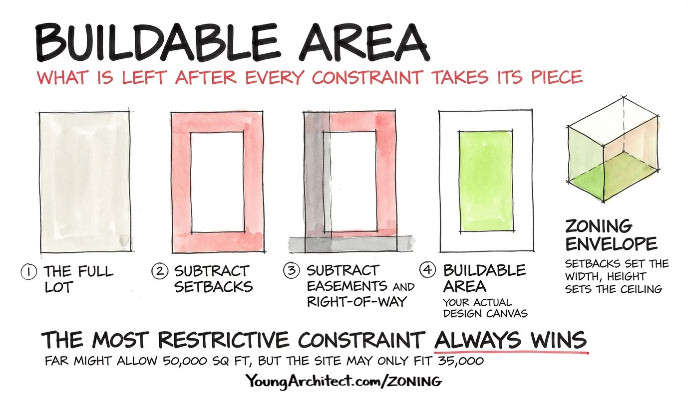
One thing to watch for: setbacks always shrink the outer perimeter of your site. But a utility or drainage easement can slice directly through the middle of a parcel, potentially splitting one site into two separate buildable envelopes.
That’s a different constraint than perimeter-based setbacks, and it can fundamentally change how you approach a site layout.
All of these constraints stack on top of each other. Setbacks create the horizontal boundaries. Height limits create the vertical ceiling. And when you overlay FAR and lot coverage on top of that, you end up with what’s essentially a three-dimensional box that your building has to fit inside. That’s your zoning envelope.
Sometimes the math of the FAR says you can build a 50,000 square foot building. But when you actually draw the setbacks, apply the height limit, and look at the lot coverage cap, the physical space left on the site only fits 35,000 square feet.
The most restrictive constraint always wins.
You know WHERE you can build. Now let’s talk about HOW MUCH.
Floor Area Ratio
Floor area ratio, or FAR, is one of the most powerful tools in zoning, and once you understand it, a lot of other things start to make sense.
The formula is simple:
Total building floor area ÷ lot area = FAR
FAR calculations use gross floor area (GFA), the total area measured to the exterior envelope across all floors. Jurisdictions vary on whether basements, mechanical space, or structured parking count toward the total. Always check the local definition.
A FAR of 2.0 means you can build twice the lot area in total floor space.
So if you’ve got a 10,000 square foot lot and your FAR is 2.0, you’re allowed 20,000 square feet of building. But here’s where it gets interesting.
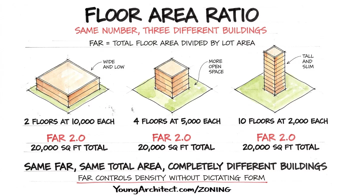
That 20,000 square feet could be:
- 2 floors at 10,000 each. A big, wide, low building that covers most of the lot.
- 4 floors at 5,000 each. A taller, narrower building with more open space around it.
- 10 floors at 2,000 each. A slender tower with a small footprint and a lot of open ground.
Same FAR. Same total area. Completely different buildings.
FAR controls density without dictating form. And that’s what makes it elegant. It gives architects design flexibility while still controlling the overall intensity of development on a site.
This is exactly the kind of site analysis and zoning evaluation you work through in the ARE Boot Camp, where we break down how to approach site constraints systematically instead of guessing.
If you’re studying for Programming and Analysis, PA 101 covers every PA objective in detail, including zoning, site analysis, and the regulatory framework that shapes what you can build.
NCARB’s published objectives point toward this concept directly. PPD Objective 2.1 specifically calls out “allowable building size based on FAR.”
Understanding how floor area ratio works and how to apply it to a given lot is exactly what that objective is pointing toward.
FAR means Floor Area Relative to the lot.
Lot Coverage and Impervious Surface
FAR controls total floor area across all the floors. But there’s a separate control that limits how much of the lot your building’s footprint can cover.
That’s lot coverage, and it’s measured as a percentage.
If your lot is 10,000 square feet and the lot coverage limit is 50%, your building footprint can’t exceed 5,000 square feet. That’s the area the building takes up on the ground, not the total floor area.
You can have low lot coverage but high FAR if you build tall. A 5,000 square foot footprint with four stories gives you 20,000 square feet of total area.
That’s 50% lot coverage but a FAR of 2.0. They measure completely different things.
- Lot coverage measures what you’re doing on the ground.
- FAR measures what you’re doing in total.
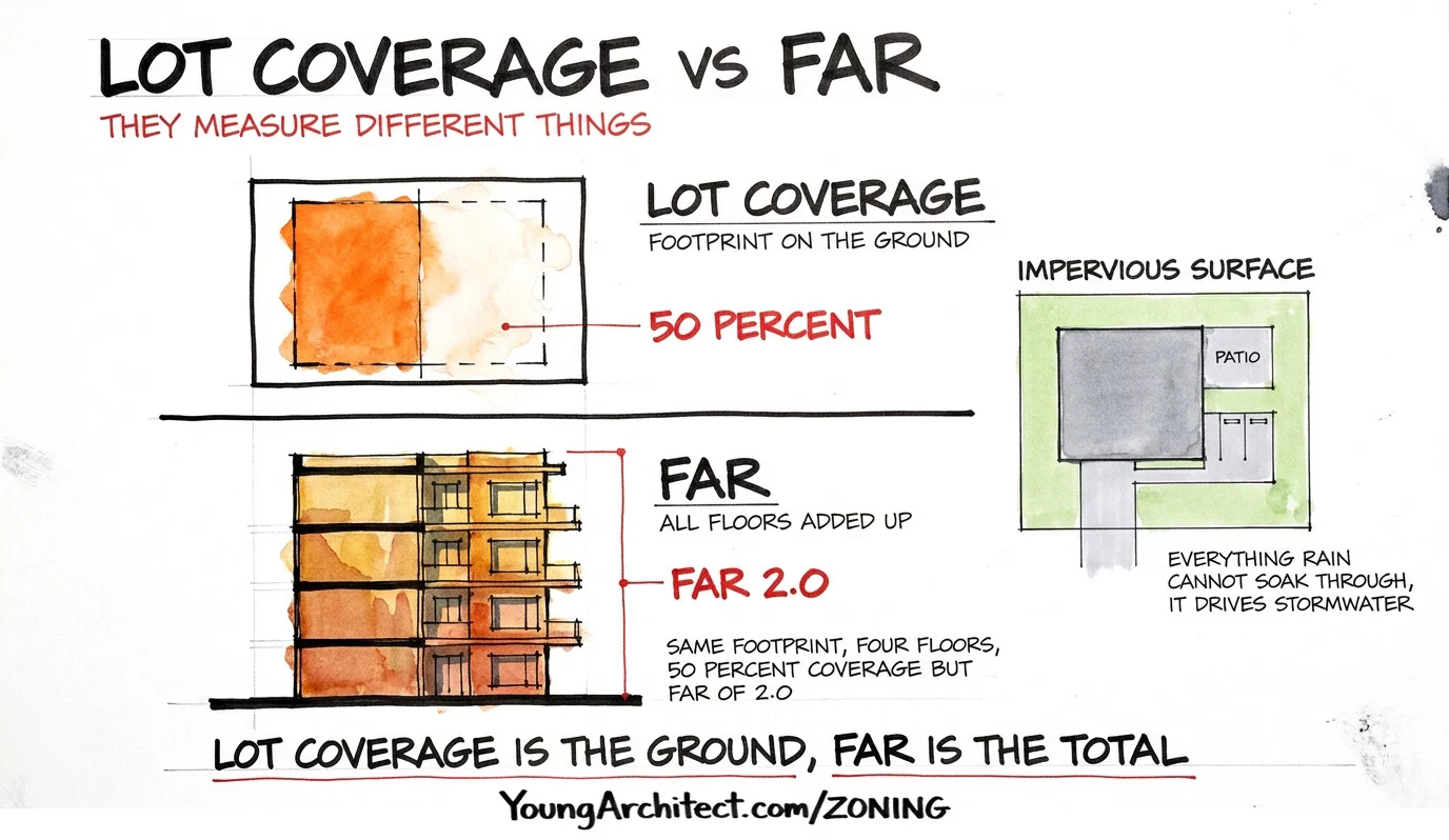
Some zoning codes go a step further and regulate impervious surface coverage. That includes not just the building footprint but also parking lots, driveways, sidewalks, and patios.
Basically anything that doesn’t let rainwater soak into the ground.
This connects directly to stormwater management, because the more impervious surface you create, the more runoff the site generates and the more you have to manage.
An unroofed concrete patio or paved driveway adds to impervious surface coverage but does NOT count toward FAR or gross floor area because it isn’t enclosed floor space. Different measurements, different rules.
Some zones also require minimum open space or green space on the site. This is related to lot coverage but specified separately.
Lot coverage means how much lot the building covers. Footprint only.
Building Height Limits
Building height limits cap how tall your building can go, measured in feet, stories, or both.
This seems straightforward. But the part that trips people up is how height is measured, because it varies by jurisdiction.
- Some codes measure from grade to the highest point of the roof
- Some measure to the midpoint of a pitched roof
- Some measure to the top of the parapet
- Some use average grade around the building perimeter as the starting point
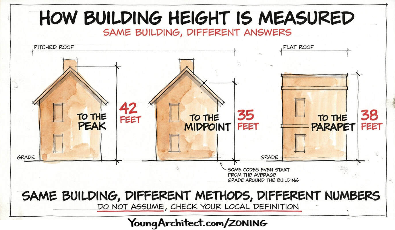
The same building could measure 35 feet under one definition and 42 feet under another.
Don’t assume how height is measured. Check the local definition. It matters more than you’d think.
Zoning Variance
Everything we’ve covered so far, the setbacks, FAR, lot coverage, height limits, those are the rules. And most of the time you design within them.
But what happens when you can’t? What happens when the rules make the site essentially unbuildable?
That’s where a zoning variance comes in.
A zoning variance is permission to deviate from a specific zoning requirement. It’s granted by the Board of Zoning Appeals or whatever the equivalent body is in your jurisdiction.
But variances are not easy to get.
You can’t just walk in and say “I’d like a bigger building, please.”
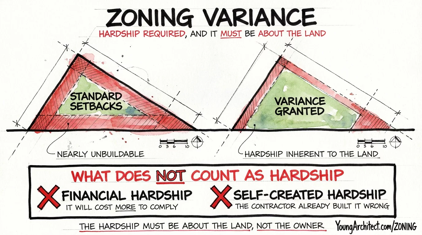
You have to demonstrate hardship, meaning the strict application of the zoning rule creates an unreasonable burden on your specific property that isn’t shared by other properties in the same zone.
And the hardship has to be about the land itself. Not the owner.
You’ve got a triangular lot. It narrows dramatically on one end. When you apply the standard side setbacks, they eat into the lot so severely that there’s barely any buildable area left. The shape of the land makes it practically impossible to build anything functional while complying with the standard setback.
That’s a hardship inherent to the property, and that’s the kind of argument that gets a variance approved.
What Does Not Qualify as Hardship
This is where candidates get tripped up constantly.
Financial hardship is not valid. “It will cost the client more money to comply” or “the client will lose profit” is not grounds for a zoning variance. Money is not a zoning hardship.
Self-created hardship is not valid either. If the contractor already poured the foundation two feet into the setback, you can’t go to the Board and say “well, it’s already built, so can we get a variance?” You created the problem. That’s not the land’s fault.
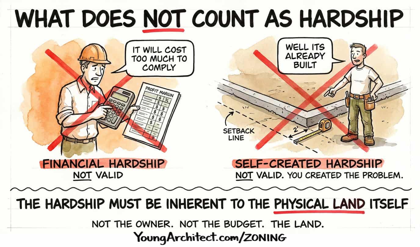
The hardship must be inherent to the physical land itself. A steep slope, a bizarre shape, an unbuildable condition that exists regardless of who owns the property.
Variance means permission to vary from the rule. Hardship required, and it has to be about the land.
Conditional Use Permit
A variance is one way to work outside the standard rules. But there’s a completely different mechanism that candidates confuse with it constantly.
A conditional use permit, also called a special exception in some jurisdictions, allows a use that’s contemplated by the zoning code but requires special approval before it can happen.
The distinction to lock in:
- Variance = about dimensions. You’re asking for relief from a setback, a height limit, or an FAR cap. The use is fine. The building just doesn’t fit the dimensional rules.
- Conditional use permit = about the use itself. The use is allowed in that zone, but it comes with potential impacts that need to be reviewed before approval.
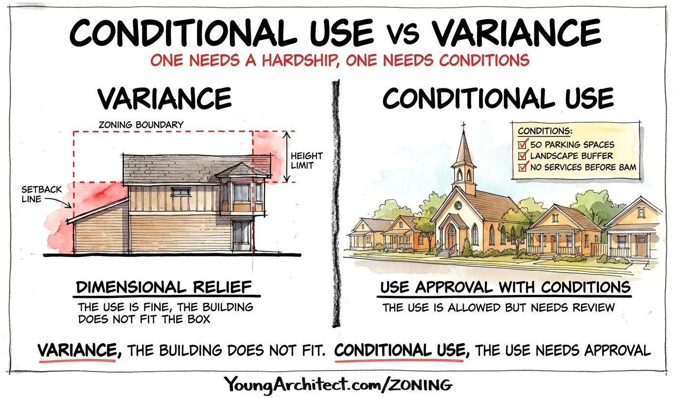
Example. A church in a residential zone. The zoning code specifically says churches are permitted in residential zones, but only with a conditional use permit. The review board looks at the impacts: How much traffic will it generate? How much parking does it need? Will it create noise issues for the neighbors?
And conditions can be attached:
- You need 50 parking spaces
- You need a landscape buffer from the neighboring houses
- Services can’t start before 8am
The use isn’t a surprise. The zoning code anticipated it. But it requires a closer look before it gets the green light.
Conditional use means the use is allowed, but conditions apply.
Nonconforming Use
What about uses that were legal when they started but don’t comply with the current zoning?
That’s a nonconforming use, and you’ve probably seen one without knowing what it was called.
Picture a corner store that’s been operating in a residential neighborhood for 60 years. When the store opened, the zoning allowed it.
But at some point, the city rezoned the area to residential-only. The store is no longer consistent with the zoning.
But it was there first. So it’s grandfathered in.
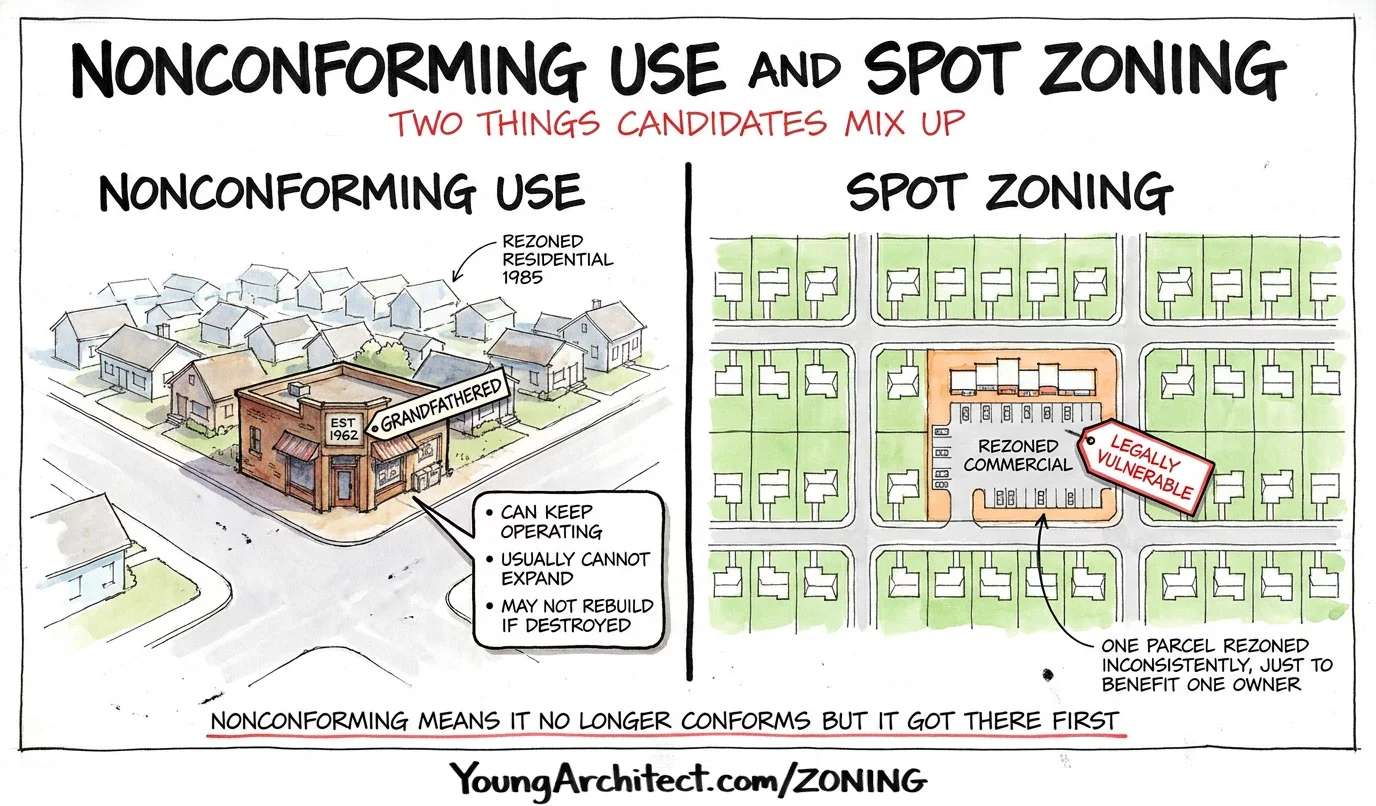
The store can usually keep operating. But most jurisdictions won’t let it expand. And the grandfathered status can be lost two ways:
- Destruction beyond a threshold. If the structure is destroyed beyond a certain percentage of its value (commonly 50% or more), many codes won’t allow it to be rebuilt under the old zoning. The nonconforming status dies with the building.
- Abandonment. If the nonconforming use is discontinued for a set period (typically 6 to 12 consecutive months), the grandfathered status expires. You can’t close the corner store for a year and then reopen it as a nonconforming use.
Spot Zoning, Upzoning, and Downzoning
A few related vocabulary terms.
Spot zoning is when a single parcel gets rezoned in a way that’s inconsistent with the surrounding area and benefits one owner rather than serving a public purpose.
If an entire neighborhood is residential and one lot gets rezoned to commercial just because the owner wants to build a strip mall, that’s spot zoning.
It’s generally considered legally vulnerable and can be challenged.
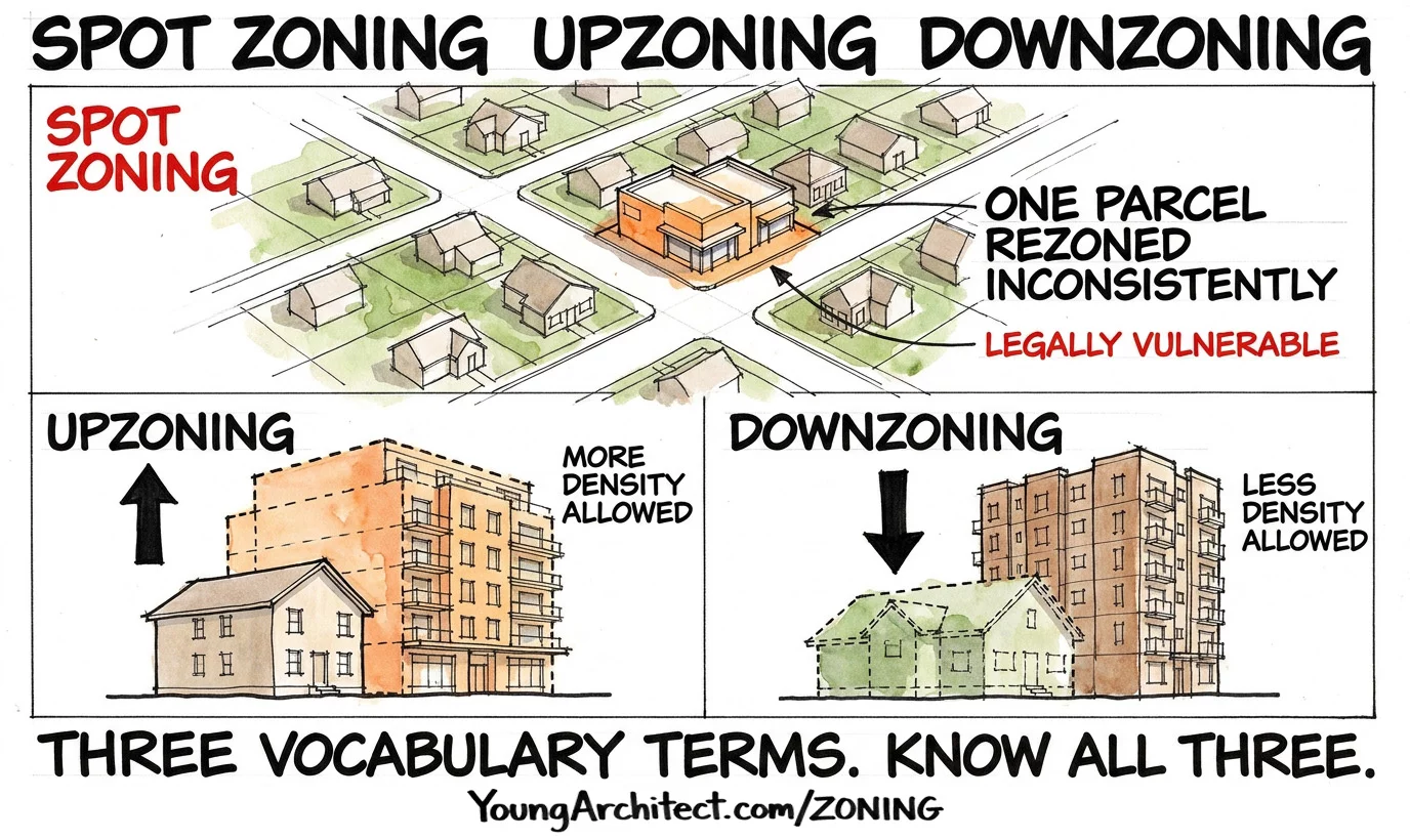
Upzoning means changing a zone to allow more density or more intense uses.
Downzoning means the opposite: reducing what’s allowed.
For a broader look at how zoning districts, nonconforming uses, and zoning boards operate, the Planning Commissioners Journal published an excellent overview on zoning basics from the Planning Commissioners Journal that covers the full framework.
Nonconforming means it doesn’t conform now, but it got there first.
Planned Unit Development
Everything we’ve talked about so far treats zoning like a rigid grid of individual lots with fixed rules. But what if you’re developing a massive corporate campus or a mixed-use neighborhood where those rigid lot-by-lot rules don’t make sense?
That’s where a planned unit development, or PUD, comes in.
A PUD is not a variance from one zoning rule. It’s a comprehensive development approval that evaluates the project as a whole.
Instead of following rigid lot-by-lot setbacks, density limits, and use restrictions, a planned unit development lets you mix uses, vary lot sizes, cluster buildings, and share open space, as long as the overall plan delivers something better than what strict zoning would produce.
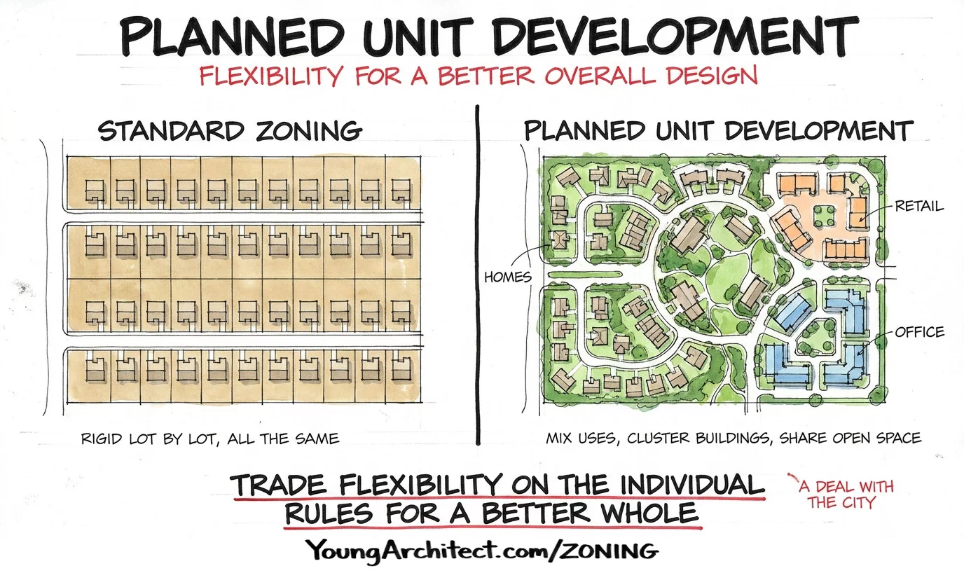
Think of it as a deal with the city. “Give us flexibility on the individual rules and we’ll create a better development overall.”
PUDs are common for large-scale projects like mixed-use neighborhoods, campus-style developments, and planned communities.
They often involve the same kinds of complex project delivery methods used on large multi-phase construction projects.
Restrictive Covenants
Everything we’ve talked about so far has been public zoning. Rules enforced by the city, the county, the planning department.
But there’s a whole other layer of restrictions that comes from private agreements. And they’re just as binding.
Restrictive covenants, also called deed restrictions, are private agreements that are written into the property deed and run with the land. They transfer when the property sells.
They’re not enforced by the city. They’re enforced by property owners, HOAs, or civil courts.
Important: A city zoning official will approve a site plan that complies with municipal zoning even if it blatantly violates an HOA covenant. The city doesn’t check private deeds. Covenant enforcement relies entirely on civil action from neighbors or the HOA.
And here’s the rule you need to know: Restrictive covenants can be more restrictive than zoning, but never less.
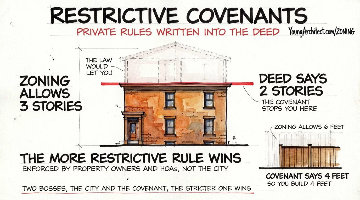
- Zoning allows 3 stories. The covenant says 2. You’re building 2 stories.
- Zoning allows a 6-foot fence. The HOA covenant says 4 feet. You’re building a 4-foot fence.
It’s like having two bosses. The city is one boss and the covenant is the other. You answer to both, and whichever one is stricter wins.
If a question gives you a zoning allowance and a deed restriction and asks which governs, the answer is always the more restrictive one.
Restrictive covenants are private rules written into the deed. Whichever is more restrictive wins.
How Zoning Shows Up on the Architect Exam
Zoning shows up across multiple ARE divisions, but the lens changes depending on which exam you’re preparing for.
Programming and Analysis (PA) focuses on identifying and evaluating zoning constraints during the initial site analysis phase. PA Objective 2.2 asks you to identify zoning and land use requirements. Every concept in this post, from setbacks to easements to FAR, is part of that initial analysis.
Project Planning and Design (PPD) focuses on applying those constraints to actual building design decisions. PPD Objective 2.1 calls out “allowable building size based on FAR.” That’s where you take the zoning envelope and turn it into a building.
If you’re working through the technical divisions, understanding the distinction between PA, PPD, and PDD helps you know which lens to apply for each exam.
NCARB’s published objectives reference these concepts directly. The vocabulary in this post isn’t just terminology. It’s the professional knowledge framework that drives site analysis, design decisions, and regulatory compliance in real practice.
Zoning Recap
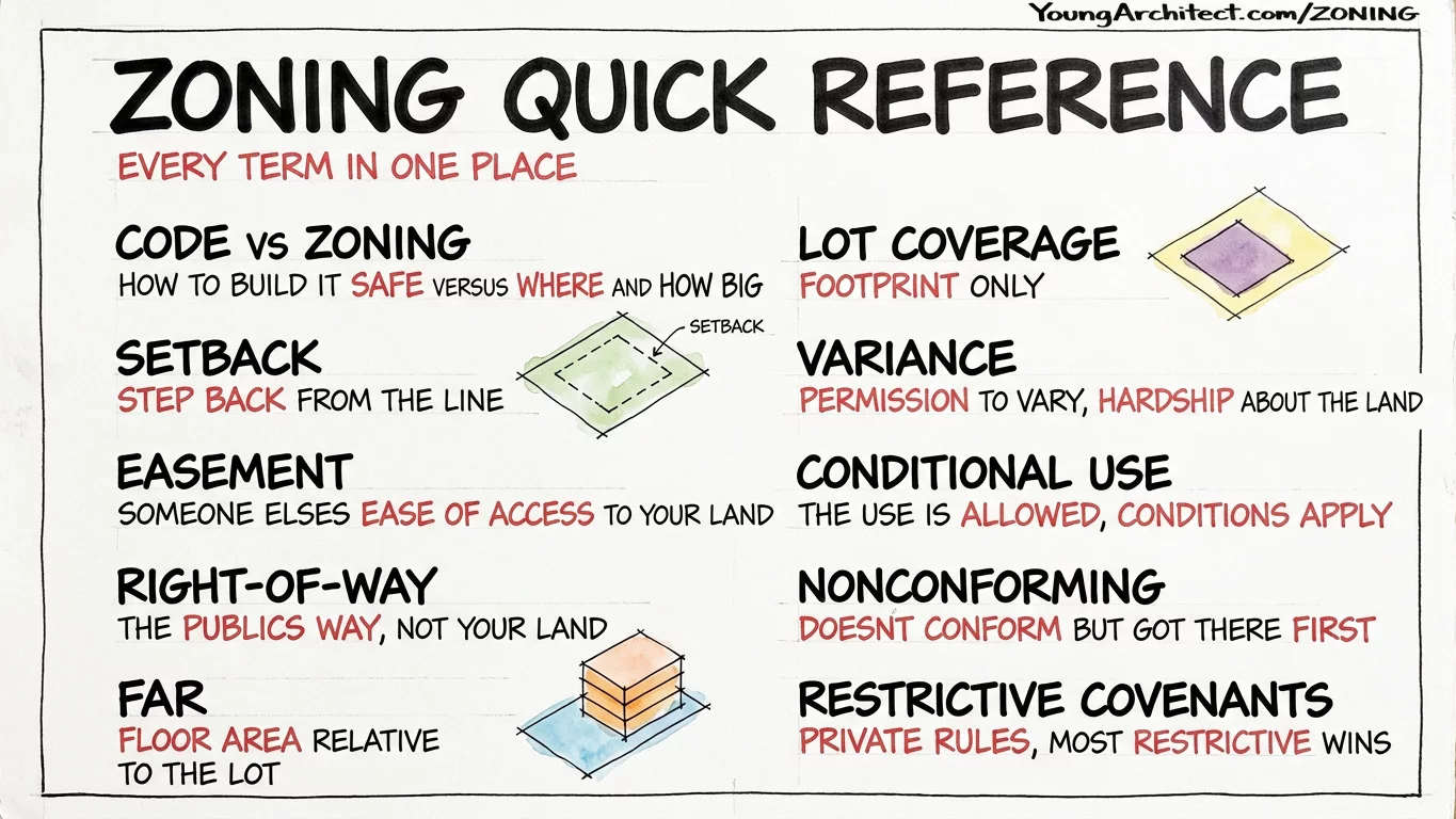
Every term, every memory hook, one place.
Zoning vs. Building Code. Code says how to build it safe. Zoning says where and how big. Different departments, different reviews.
Setbacks. Step back from the property line. Cross the setback and that’s an encroachment. Always check the plat.
Easements. Your land, but someone else has rights to use it. Can’t build permanent structures in them. They run with the land and transfer with the deed.
Right-of-Way. Not your land at all. Public property. Your property line starts at the edge.
Buildable Area. Subtract setbacks, easements, and rights-of-way from your lot. What’s left is your design canvas.
Floor Area Ratio (FAR). Total floor area divided by lot area. Same FAR can produce completely different building forms. FAR means Floor Area Relative to the lot.
Lot Coverage. How much lot the building covers. Footprint only. Different from FAR.
Height Limits. Check the local definition. Same building, different measurement methods, different numbers.
Zoning Variance. Permission to vary from the rule. Hardship required, and it has to be about the land. Not the owner. Not the budget.
Conditional Use Permit. The use is allowed, but conditions apply. About the use, not the dimensions.
Nonconforming Use. Doesn’t conform now, but it got there first. Grandfathered in, but can’t expand.
Restrictive Covenants. Private rules written into the deed. The city won’t enforce them. Whichever rule is more restrictive wins.

If you want to go deeper on zoning, site analysis, and all the regulatory content that shapes how projects get approved, the Young Architect Academy has you covered.
ARE Boot Camp is built for candidates who need more than study materials. It gives you a curriculum, accountability, time management strategies, and a clear structure to follow so you’re actually studying instead of spinning your wheels trying to figure out what to study.
The ARE 101 Membership gives you access to every course in the Academy.
PA 101 covers every Programming and Analysis objective in detail, including the zoning and land use content we walked through today.
PPD 101 covers the design side, how you actually apply zoning constraints to building design decisions like massing, site layout, and parking.
Building Codes 101 covers the other side of the equation, the building code concepts like occupancy classifications, construction types, egress, and fire protection that the building department reviews after zoning is cleared.
Frequently Asked Questions
What is an easement on a property?
An easement is a legal right for someone else to use a portion of your land for a specific purpose. You still own the property and pay taxes on it, but someone else has rights to access or use part of it. Common types include utility easements for power and water infrastructure, drainage easements that protect water flow paths, and access easements that let a landlocked neighbor cross your property. Easements run with the land and transfer when the property sells.
What is a restrictive covenant?
A restrictive covenant is a private agreement written into a property deed that limits what an owner can do with the land. Unlike zoning, which is enforced by the city, covenants are enforced by property owners, HOAs, or civil courts. Covenants can be more restrictive than zoning but never less. If zoning allows three stories but the covenant limits the property to two, you build two stories. Whichever rule is more restrictive governs.
What is a planned unit development?
A planned unit development is a zoning mechanism that lets a developer propose a comprehensive site plan that can deviate from standard zoning rules. Instead of rigid lot-by-lot setbacks and use restrictions, a PUD allows mixed uses, varied lot sizes, clustered buildings, and shared open space, as long as the overall plan delivers a better result than strict zoning would produce. PUDs are common for large-scale mixed-use neighborhoods and campus developments.
What is the difference between an easement and a right-of-way?
An easement is a right to use someone else’s land for a specific purpose, but the property owner still owns the land. A right-of-way is land dedicated to public use, typically for streets, sidewalks, and utilities. The owner does not own right-of-way land at all. Both limit where you can build on a site, but for different legal reasons. Easements restrict your property. Rights-of-way are not your property.
What is a zoning variance?
A zoning variance is permission to deviate from a specific zoning requirement, like a setback, height limit, or FAR cap. It is granted by the Board of Zoning Appeals and requires demonstrating hardship. The hardship must be inherent to the physical land itself, not the owner’s financial situation or a problem the owner created. A common example is an oddly shaped lot where standard setbacks leave almost no buildable area.
Zoning Fundamentals Quiz Time: